
Robin Hood's Butts (Brow Moor)
| Locality | |
|---|---|
| Coordinate | 54.40374, -0.518758 |
| Adm. div. | North Riding of Yorkshire |
| Vicinity | Brow Moor, 1.8 km W of Ravenscar |
| Type | Prehistoric site |
| Interest | Robin Hood name |
| Status | Extant |
| First Record | 1772 |


By Henrik Thiil Nielsen, 2013-08-06. Revised by Henrik Thiil Nielsen, 2021-05-31.
Robin Hood's Butts are three round barrows on the crest of Stoupe Brow, Brow Moor, 225 m above sea level, not quite 2 km from Ravenscar. They lie about 1 km inland from the south end of Robin Hood's Bay and c. 3.5 km SSW of Robin Hood's Bay town.
The mounds were known as Robin Hood's Butts by 1772, when Jeffery's Map of Yorkshire was first published; they are included also on eesdale's 1828 map (see map detail, Maps section and image gallery on the present page). Until some time before 1772, and from at least as early as 1682, the name was applied to two mounds c. 1.4 km to the SE which are now known as Beacon Howes. Made of earth and stone, the three mounds on Stoupe Brow are all scarred by quarrying for stones (probably during the Bronze Age), 19th century excavations, and the construction of a WWII gun pit. Their approximate diametres are 17, 18 and 21 m. There are traces of an outer ditch and counterscarp bank around each of the two largest mounds.[1]
See the page on places named Robin Hood's Butts for a general discussion and list of such names.Allusions
1817 - Young, George - History of Whitby (2)
Nearer [than Stainton Dale] to Whitby is the inlet called Robin Hood's Bay, in the north-west part of which there is a fishing town of the same name, of a romantic appearance, containing about 1000 inhabitants. The village and bay derive their name from the celebrated outlaw Robin Hood, who is said to have frequented the spot.§ [...]
[Note §:] This Robin Hood (or Robert earl of Huntington) celebrated for his predatory exploits, is said to have died in the year 1247. According to tradition, he and his trusty mate Little John went to dine with one of the abbots of Whitby, and being desired by the abbot to try how far each of them could shoot an arrow, they both shot from the top of the abbey, and their arrows fell on the west side of Whitby Lathes, beside the lane leading from thence to Stainsacre; that of Robin Hood falling on the north side of the lane, and that of Little John about 100 feet further, on the south side of the lane. In the spot where Robin's arrow is said to have lighted stands a stone pillar about a foot square, and 4 feet high; and a similar pillar 2½ feet high, marks the place where John's arrow fell. The fields on the one side are called Robin Hood closes, and those on the other Little John closes. They are so termed in the conveyance, dated in 1713, from Hugh Cholmley, Esq. to John Watson, ancestor to the present proprietor, Mr. Rob. Watson. The tradition is scarcely credible, the distance of those pillars from the abbey being about a mile and a half. Much more incredible is the tradition, that Robin shot an arrow from the height where Stoupe Brow beacon is placed, right across the bay to the town which bears his name; having resolved to build a town where the arrow lighted. To the south of that beacon are two or three tumuli or barrows, called Robin Hood's butts; from a fabulous story of his using them as butts, when he exercised his men in shooting.[2]
Gazetteers
- Dobson, R. B., ed.; Taylor, J., ed. Rymes of Robyn Hood: an Introduction to the English Outlaw (London, 1976), p. 306, s. n. 'Robin Hood's Butts' [3].
Sources
Maps
- Jefferys, Thomas, cartog. The County of York. Survey'd in MDCCLXVII., VIII., IX., and MDCCLXX (London, 1772), sheet 4, row 2, tiles 2-3
- Teesdale, Henry. Map of Yorkshire (London, 1828)
- Yorkshire 6" O.S. map Yorkshire 47 (1853, surveyed 1849)
- Yorkshire 6" O.S. map Yorkshire XLVII.SW (1895, surveyed 1891-92)
- Yorkshire 6" O.S. map Yorkshire XLVII.SW (1914, surveyed 1910)
- Yorkshire 6" O.S. map Yorkshire XLVII.SW (1930, surveyed 1926)
- Yorkshire 6" O.S. map Yorkshire XLVII.SW (1952, surveyed 1950)
- 1:25,000 O.S. map NZ90 & Parts of NZ91 (1954.)
Also see
Notes
Image gallery
Click any image to display it in the lightbox, where you can navigate between images by clicking in the right or left side of the current image.
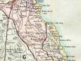
Robin Hood's Butts / Henry Teesdale's Map of Yorkshire (1828).
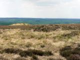
Robin Hood's Butts / Andrew Curtis, May 23, 2010.
